Grand-35 Project
The Arizona Department of Transportation (ADOT), in coordination with the City of Phoenix and Maricopa Association of Governments, is designing improvements to the intersection of US 60 (Grand Avenue), 35th Avenue and Indian School Road.
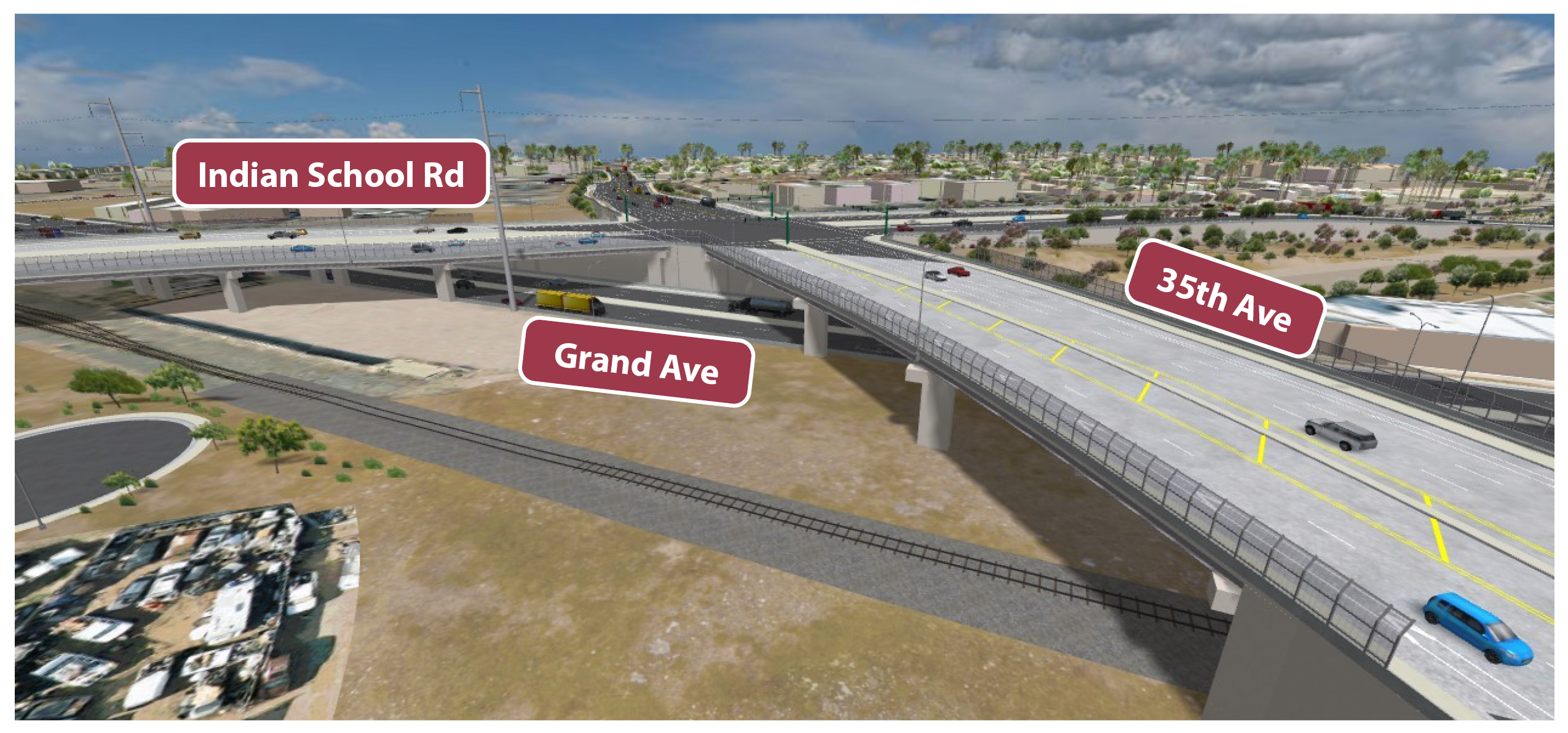
The project will raise 35th Avenue to create a new elevated intersection with Indian School Road above Grand Avenue, which will improve traffic operations and safety and reduce vehicle/train conflicts. The project also includes improvements to sidewalks and bicycle facilities and will modify other roadways in the project area to provide local access.
 Rendering of future intersection
How to Navigate:
- Click the arrows at the bottom of your screen to advance through each page.
- Use the tabs on the left side of the screen to visit a specific section.
Project Overview
The Grand-35 Project will reconstruct the intersection of Grand Avenue, 35th Avenue and Indian School Road to improve traffic flow and safety and reduce vehicle-train conflicts. The project will create a new elevated intersection of 35th Avenue and Indian School Road over Grand Avenue, allowing traffic on Grand Avenue to flow freely and eliminating vehicle crossings with the BNSF Railroad. The project will also include modifying other local roadways in the area to provide connectivity and maintain access to properties. See the Project Improvements tab for more details on the specific improvements.
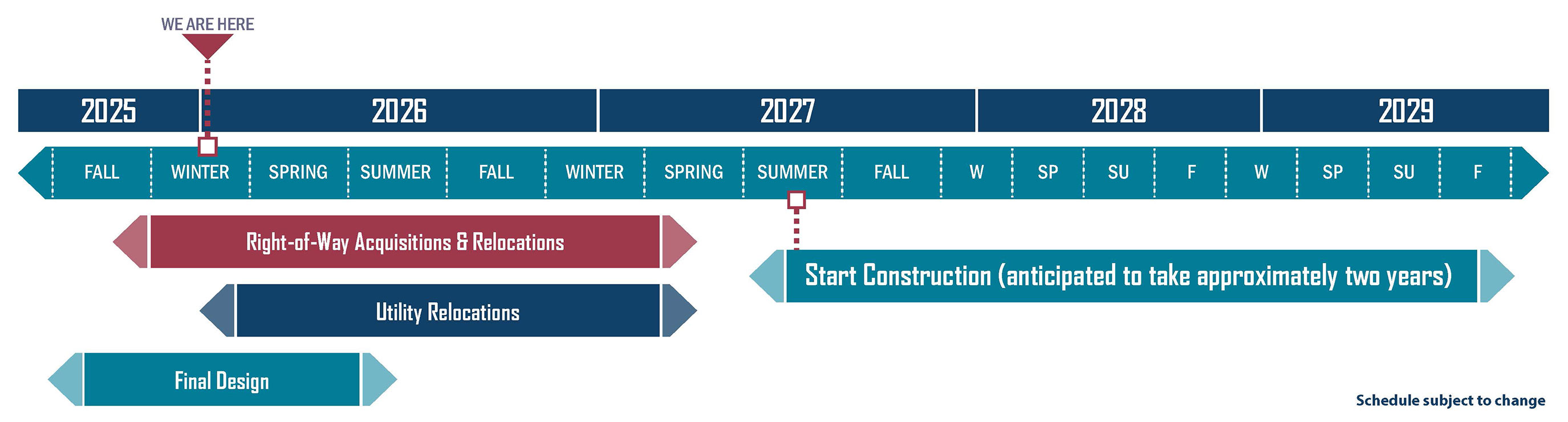
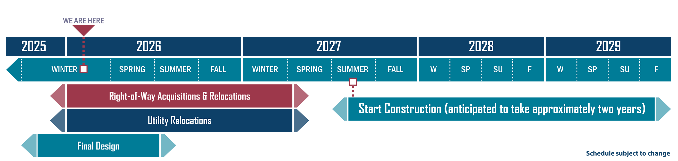
ADOT released the final Environmental Assessment and Design Concept Report and a Finding of No Significant Impact for the proposed project in summer 2024, which allowed the project to advance to the final design phase and begin needed right of way acquisition. The project is currently in the final design phase with construction expected to begin in summer 2027.
Click the image above to enlarge.
Timeline
Click the images above to enlarge.
- Final Design - Late 2025 to Summer 2026
- Right of Way Acquisitions & Relocations, and Utility Relocations - Late 2025 to Spring 2027
- Alternative Concepts Meeting - Winter 2026
- Start Construction - anticipated to last approximately two years starting in Summer 2027 Schedule subject to change
Project Improvements
Improvements
Project improvements include:
- Shifting 35th Avenue to the west. 35th Avenue would also be elevated to create a new intersection with Indian School Road.
- Indian School Road would be shifted to the north and would be elevated to create a new intersection with 35th Avenue.
- Both 35th Avenue and Indian School Road would pass over Grand Avenue and the BNSF Railway.
- An elevated signalized intersection would be created between 35th Avenue and Indian School Road.
- Two lanes would be provided in each direction of travel on 35th Avenue.
- Three lanes would be provided in each direction of travel on Indian School Road.
- Three lanes would be provided in each direction of travel on Grand Avenue and Grand Avenue would remain at-grade.
- Glenrosa Avenue would be extended to the west to create a new connector road that would restore connectivity between 35th Avenue and Grand Avenue.
- West of 35th Avenue, Clarendon Avenue would be realigned to connect to Clarendon Avenue east of 35th Avenue and eliminate the existing offset intersection at 35th Avenue.
- 33rd Avenue would be extended north of Indian School Road and a new east-west local road would extend from 33rd Avenue to 35th Avenue. 33rd Drive would connect to the new east-west local road.
Click the image above to enlarge.
Video Rendering
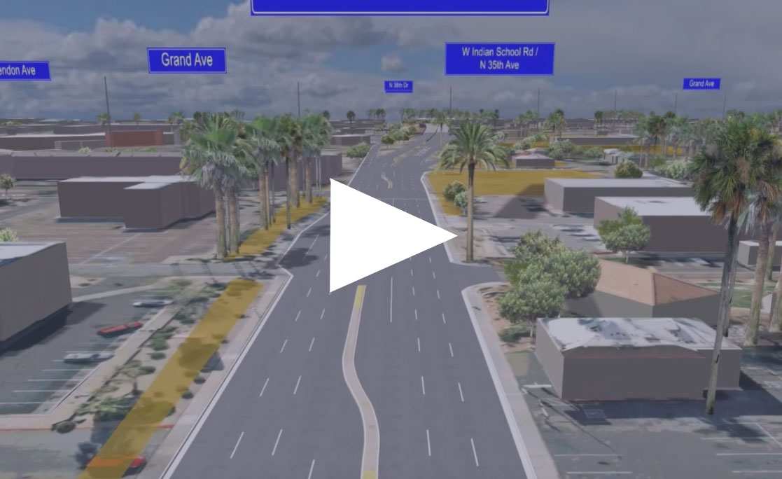
Renderings
- Looking west on Indian School Road west of 36th Avenue
- Westbound Indian School Road east of 35th Avenue
- Looking south on 35th Avenue south of Glenrosa Avenue
- Looking west on Indian School Road west of 33rd Avenue (view 1)
- Looking west on Indian School Road west of 33rd Avenue (view 2)
- Looking west on Indian School Road west of 35th Avenue (view 1)
- Looking west on Indian School Road west of 35th Avenue (view 2)
- Looking north on 35th Avenue south of Indian School Road
- Looking north on 35th Avenue south of Glenrosa Avenue
- Looking northwest on Grand Avenue west of 33rd Avenue
- Looking northwest on Grand Avenue near 35th Avenue
- Looking northwest on Grand Avenue southeast of 37th Avenue
- Looking east on Indian School Road east of 38th Avenue
- Looking north on 35th Avenue from Clarendon Avenue
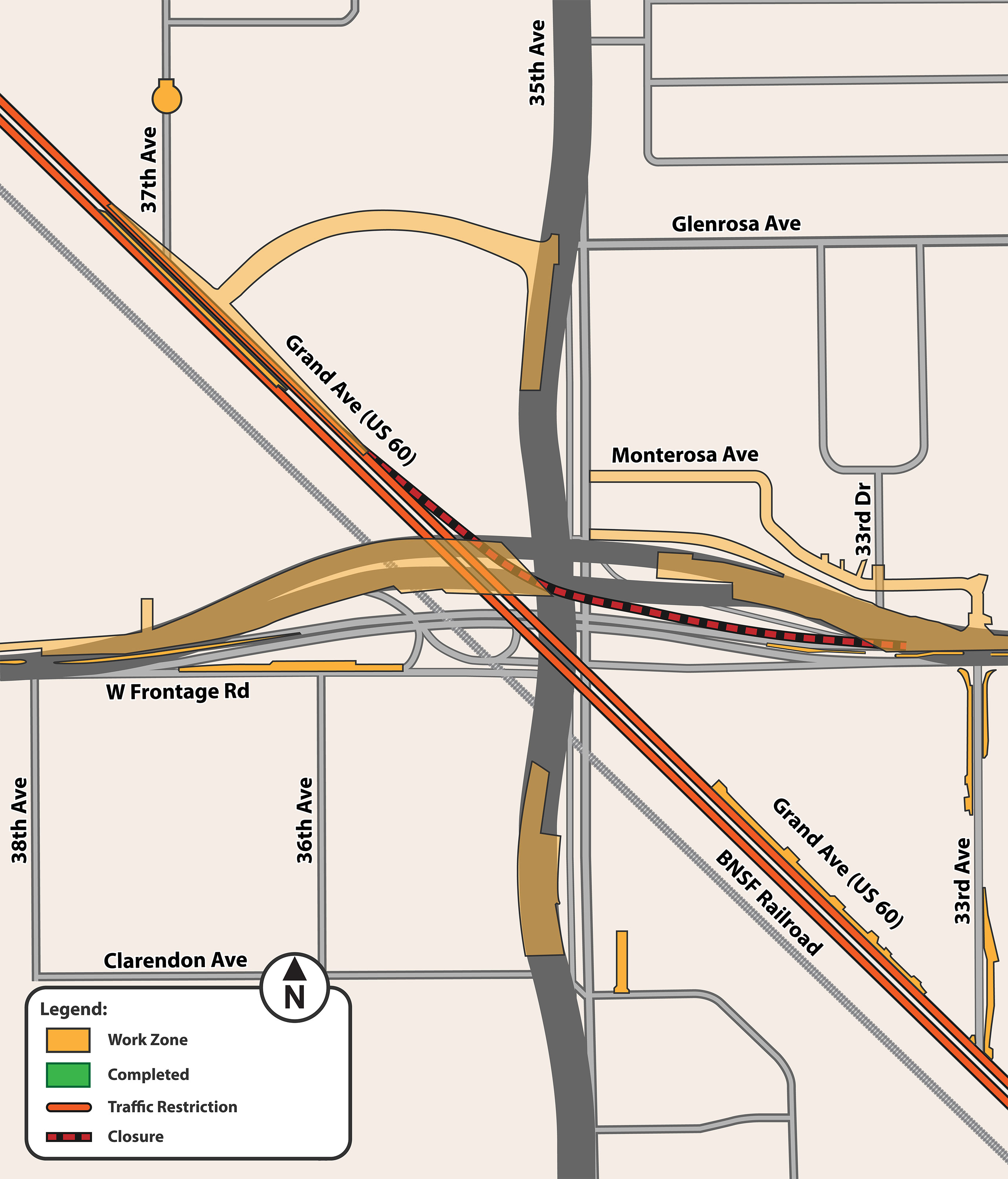
Construction Phasing
Overview
Construction is expected to begin in Summer 2027 and take approximately two years to complete. The following restrictions and closures are anticipated:
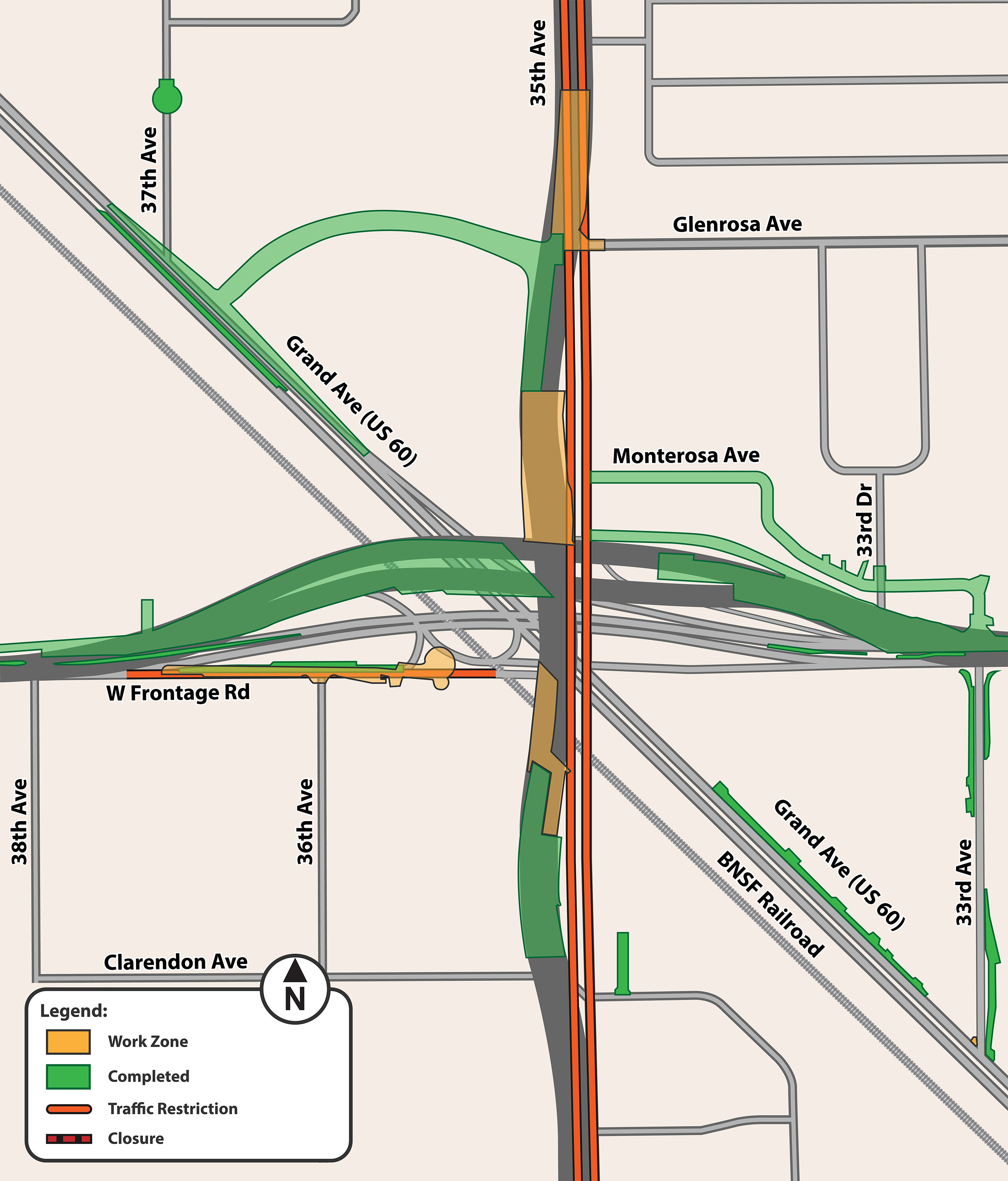
Phase 1 (approximately 10 months)
- The majority of construction will be offset from existing roadways
- Will include lane closures along Grand Avenue from 37th Avenue to 33rd Avenue
- Will close westbound Indian School Road to northbound/westbound Grand Avenue ramp for approximately 1.5 years
- Short-term closures on Grand Avenue (nights and/or weekends)
Click the images above to enlarge.
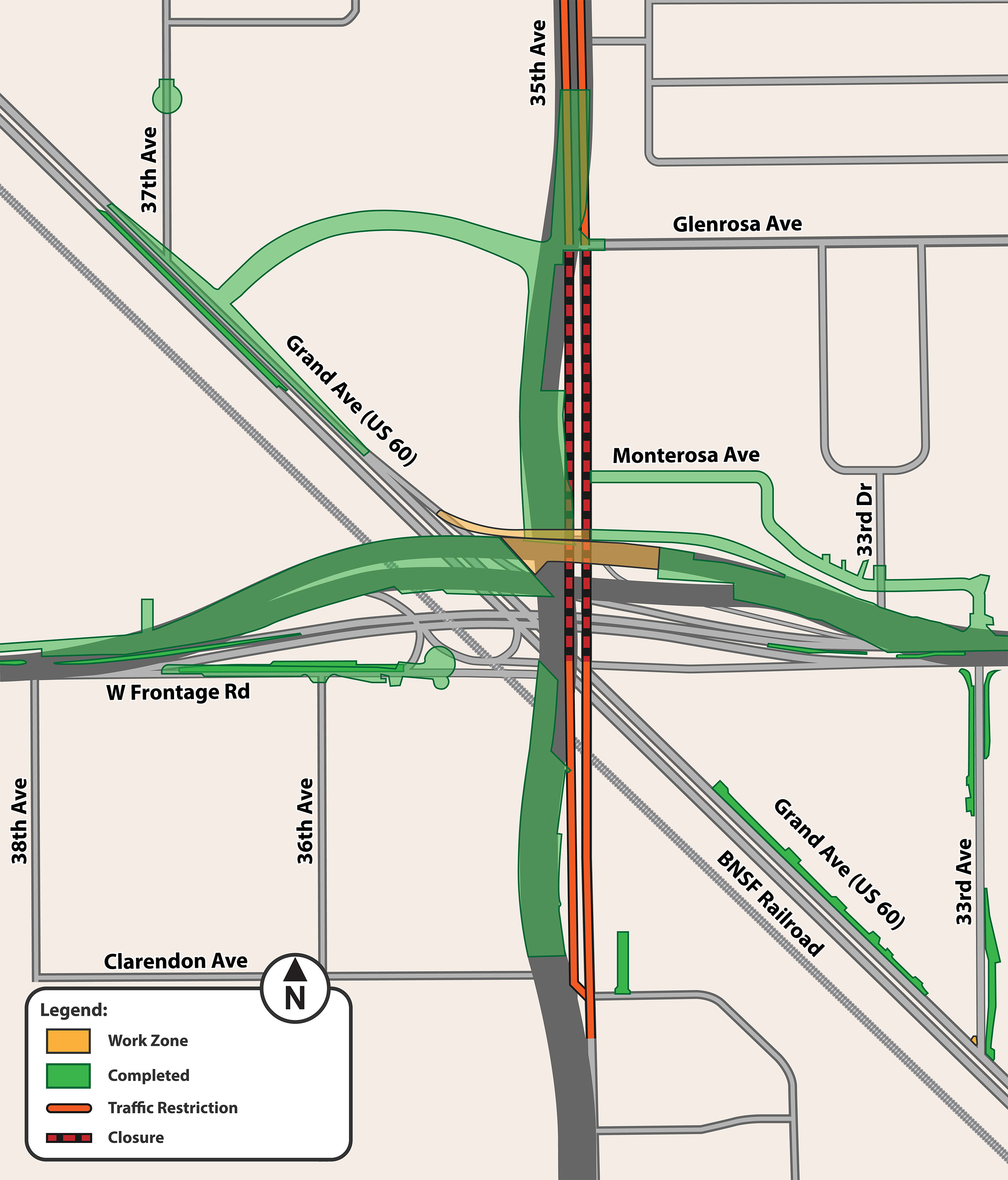
Phase 2 (approximately 6 months)
- Lane closures along 35th Avenue from Turney Avenue to Clarendon Avenue
- 35th Avenue construction will be done in halves to maintain access and preserve parking areas during residential driveway construction
Click the images above to enlarge.
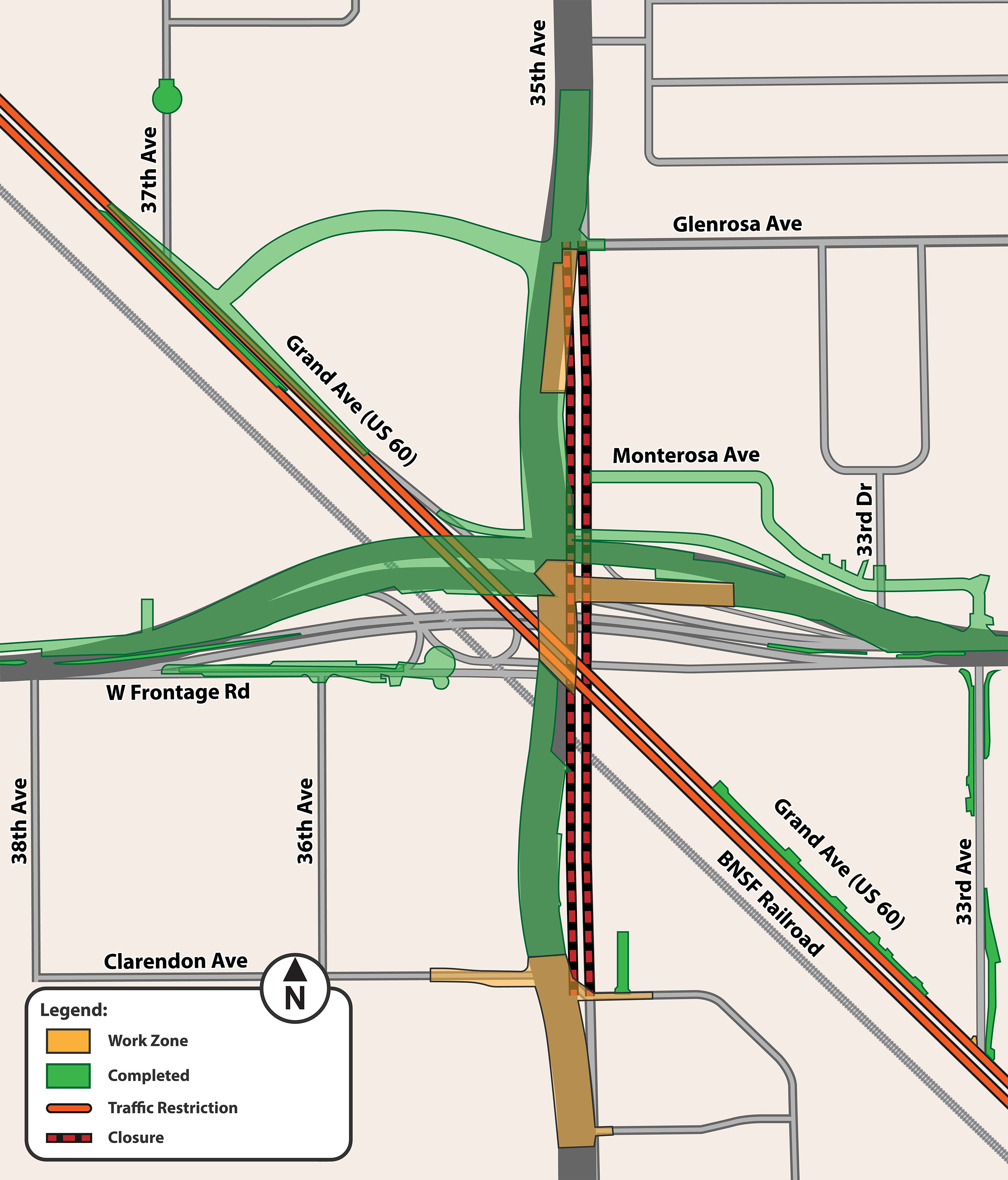
Phase 3 (approximately 2 months)
- Lane closures along 35th Avenue from Grand Avenue to Clarendon Avenue and from Turney Avenue to Glenrosa Avenue
- Close 35th Avenue from Grand Avenue to Glenrosa Avenue
- Indian School Road traffic will be shifted to the new roadway, operating on a reduced number of lanes at the end of Phase 3
Click the images above to enlarge.
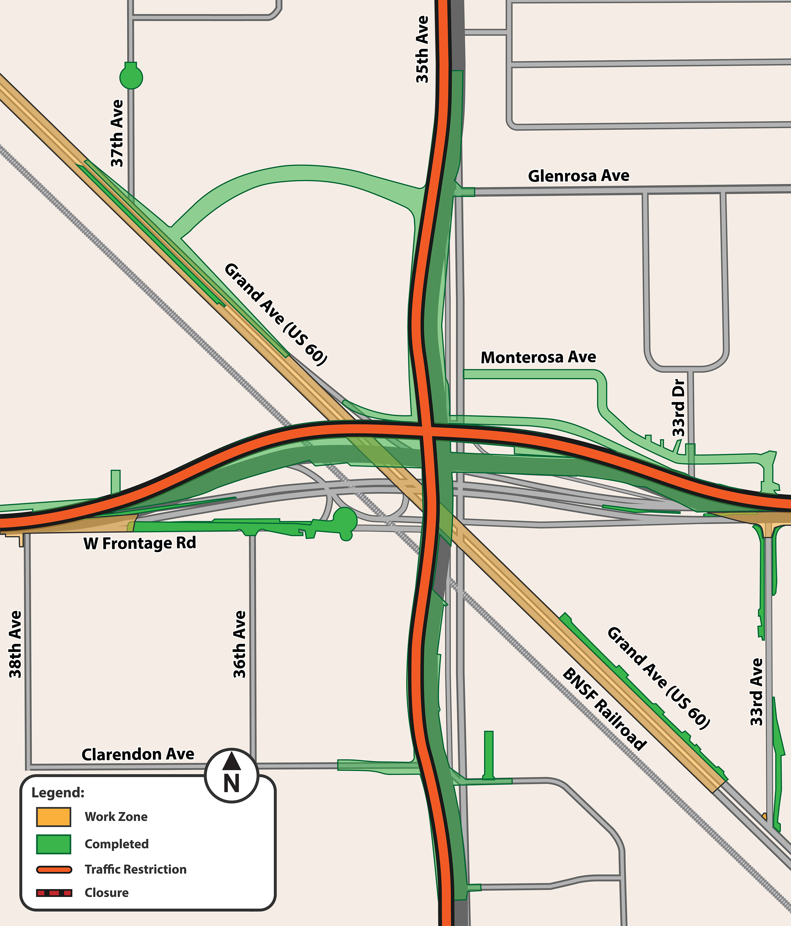
Phase 4 (approximately 7 months)
- 35th Avenue closed between Glenrosa Avenue and Clarendon Avenue (approximately 7 months)
- Lane closures along Grand Avenue at 35th Avenue
- Short-term closures on Grand Avenue (nights and/or weekends)
- 35th Avenue traffic will be shifted to the new roadway, operating on a reduced number of lanes at the end of Phase 4
Click the images above to enlarge.
Phase 5 (approximately 4 months)
- Lane closures along Indian School Road and 35th Avenue
- Lane closures along Grand Avenue from 37th Avenue to 33rd Avenue
Click the images above to enlarge.
Project Schedule
Click the images above to enlarge.
- Final Design - Late 2025 to Summer 2026
- Right of Way Acquisitions & Relocations, and Utility Relocations - Later 2025 to Spring 2027
- Alternative Concepts Meeting - Winter 2022
- Start Construction - anticipated to last approximately two years starting in Summer 2027 Schedule subject to change
Late 2026
Complete final design plans
Early spring 2027
Complete right of way acquisitions/relocations and utility relocations
Summer 2027
Begin construction (anticipated two-year duration)